Thursday 28 March 2024

Point Clouds for Seamless CAD-Based As-Built Drawings

 Introduction:

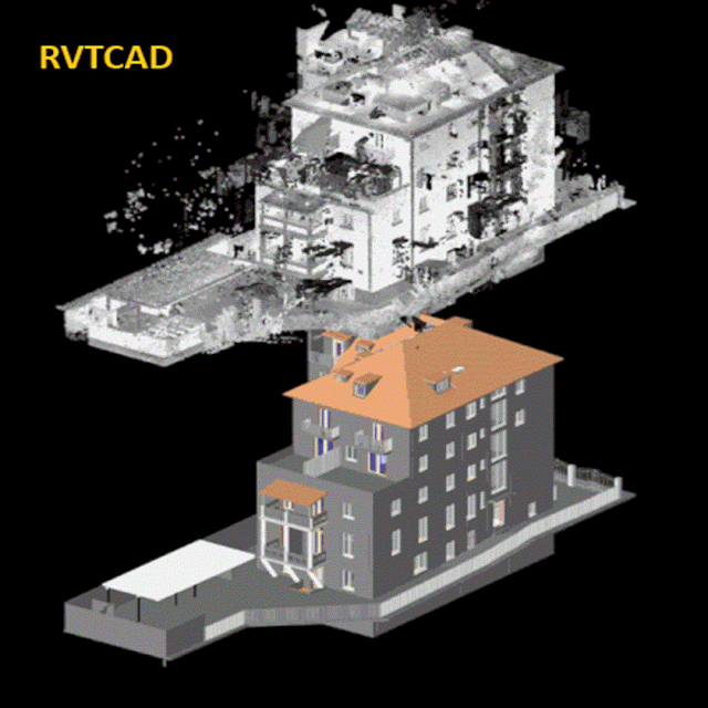
In the domain of architectural, engineering, and construction (AEC) industries, accurate documentation of as-built conditions is crucial for project success. Traditionally, creating as-built drawings involved time-consuming manual measurements and interpretation of existing structures. However, with advancements in technology, the integration of point cloud data into computer-aided design (CAD) platforms has revolutionized the process, offering unprecedented precision and efficiency.


point cloud to bim, as-built drawings


Understanding Point Clouds:

·         Point clouds are dense collections of data points in three-dimensional space, generated through 3D laser scanning or photogrammetry techniques. These data points represent the precise geometry and spatial attributes of real-world objects, capturing intricate details of existing structures, landscapes, or environments. By utilizing specialized scanners and software, professionals can swiftly capture vast amounts of data, creating comprehensive representations of physical spaces. Furthermore, the high level of detail provided by point clouds enables accurate reconstruction of complex architectural elements and structural components, enhancing the fidelity of CAD-based as-built drawings. Additionally, point cloud technology facilitates remote data capture, allowing for the documentation of hard-to-reach or hazardous environments without compromising safety.


Seamless Integration with CAD:

·         The smooth incorporation of point cloud data into CAD environments has greatly enhanced the efficiency of producing as-built drawings. CAD software allows users to import point cloud datasets directly, providing a foundation for accurate modeling and documentation. This integration facilitates precise visualization and manipulation of as-built conditions within a familiar CAD interface, empowering designers, engineers, and architects to work efficiently and collaboratively. Moreover, it reduces the need for manual measurements, saving time and minimizing errors in the drafting process. Additionally, the ability to overlay point cloud data onto existing CAD models enables thorough analysis and comparison, ensuring comprehensive understanding and documentation of real-world structures.


Enhanced Accuracy and Visualization:

·         One of the primary advantages of utilizing point clouds for as-built drawings is the unparalleled level of accuracy they offer. Unlike traditional measurement methods, which may be prone to human error or limitations in precision, point clouds provide a comprehensive and highly detailed representation of existing structures. This accuracy ensures that CAD-based as-built drawings reflect the true dimensions and spatial relationships of physical elements, minimizing discrepancies and potential rework during the design and construction phases.


·         Furthermore, point cloud data enables immersive visualization of as-built conditions, allowing stakeholders to explore virtual representations of real-world environments with unparalleled fidelity. By overlaying point clouds onto CAD models, professionals can gain insights into spatial relationships, identify potential clashes or conflicts, and make informed decisions regarding design modifications or renovations. This enhanced visualization capability enhances communication and coordination among project teams, fostering collaboration and minimizing costly errors.


Efficiency in Documentation and Analysis:

·         In addition to enhancing accuracy and visualization, the integration of point clouds with CAD expedites the documentation process for as-built drawings. Traditional methods of manual measurement and drafting are time-consuming and labor-intensive, requiring extensive fieldwork and subsequent interpretation of collected data. In contrast, point cloud technology enables rapid data acquisition, capturing detailed information about existing conditions in a fraction of the time.


·         Once integrated into CAD software, point cloud data acts as a guide for generating meticulous as-built drawings. Designers can leverage specialized tools to extract key geometric features, generate accurate floor plans, elevations, and sections, and annotate details directly within the CAD environment. This streamlined workflow accelerates the production of as-built documentation while maintaining high levels of accuracy and consistency across drawings.


·         Moreover, point cloud data facilitates advanced analysis and simulation capabilities within CAD environments. By leveraging the rich spatial information contained within point clouds, designers can perform clash detection, structural analysis, and environmental simulations to evaluate design feasibility and optimize performance. These analytical tools empower decision-making throughout the project lifecycle, from initial design concepts to facility management and maintenance.


Conclusion:

In conclusion, Rvtcad the integration of point clouds into CAD environments has transformed the process of creating as-built drawings, offering unparalleled precision, efficiency, and visualization capabilities. By leveraging advanced scanning technology and CAD software, professionals can capture, model, and document existing conditions with unprecedented accuracy and detail. This seamless integration enhances collaboration, accelerates project timelines, and facilitates informed decision-making, ultimately driving greater efficiency and success in AEC projects. As the adoption of point cloud technology continues to expand, its role in shaping the future of as-built documentation is poised to become even more pronounced.

Tuesday 26 March 2024

Point Cloud to BIM Modeling Services Tailored for Your Needs

 Introduction:

In the realm of architecture, engineering, and construction (AEC), precision and efficiency are paramount. As technology continues to advance, so do the tools and methods available to industry professionals. One such advancement that has revolutionized the way projects are conceptualized and executed is Point Cloud to Building Information Modeling (BIM) modeling services. These services offer a tailored approach to transforming raw data into comprehensive models, providing a foundation for informed decision-making, streamlined workflows, and ultimately, project success.

point cloud to bim


Understanding Point Cloud to BIM Modeling:

·         Before delving into the benefits and applications, it's essential to grasp the fundamentals of Point Cloud to BIM modeling. Point clouds are dense sets of data points captured by 3D laser scanning technology, offering a detailed representation of a physical space or structure. These data points contain precise geometric information, such as coordinates and color values, creating a digital replica of the scanned environment.


·         BIM, on the other hand, is a digital representation of the physical and functional characteristics of a building or infrastructure asset. It encompasses geometry, spatial relationships, geographic information, and other relevant properties, enabling stakeholders to visualize, simulate, and analyze various aspects of a project.


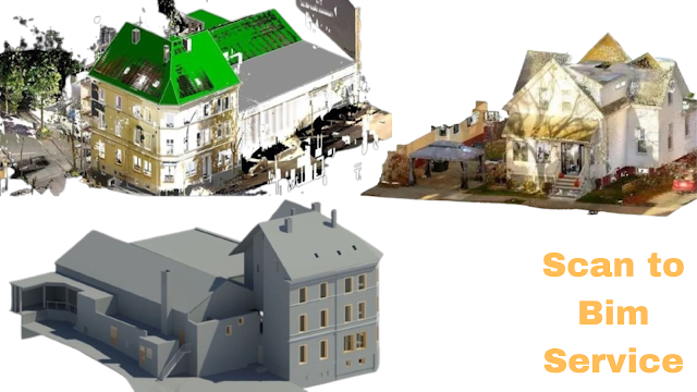
·         Point Cloud to BIM modeling bridges the gap between these two technologies by converting raw point cloud data into intelligent BIM models. This process involves extracting relevant information from the point cloud, such as building elements, dimensions, and spatial relationships, and structuring it into a coherent BIM framework. The result is a highly detailed and accurate digital representation that serves as a foundation for design, analysis, and collaboration throughout the project lifecycle.

Tailored Solutions for Diverse Needs:

·         One of the most significant advantages of Point Cloud to BIM modeling services is their adaptability to diverse project requirements and industry sectors. Whether it's renovation projects in the architectural domain, infrastructure development in civil engineering, or facility management in construction, these services can be tailored to meet specific needs and challenges.


·         For architects and designers, Point Cloud to BIM modeling offers invaluable insights into existing structures, facilitating the renovation, retrofitting, or adaptive reuse of buildings. By accurately capturing as-built conditions and incorporating them into the design process, architects can make informed decisions, minimize errors, and optimize space utilization.


·         In the realm of civil engineering and infrastructure, Point Cloud to BIM modeling plays a crucial role in asset management, maintenance, and planning. By generating detailed 3D models of bridges, roads, and utilities from point cloud data, engineers can assess structural integrity, identify potential hazards, and optimize maintenance schedules, ensuring the longevity and safety of critical infrastructure assets.


·         Construction firms also benefit from Point Cloud to BIM modeling services by enhancing project coordination, scheduling, and quality control. By integrating as-built data into construction workflows, project teams can detect clashes, resolve conflicts, and verify progress against design specifications, minimizing rework and costly delays.


Advantages Beyond Traditional Methods:

Compared to traditional surveying and modeling techniques, Point Cloud to BIM modeling offers several distinct advantages:

1. Precision and Accuracy: Point cloud data provides a level of detail and accuracy that surpasses conventional surveying methods, ensuring that BIM models are true representations of the physical environment.

2. Efficiency and Time Savings: By automating the conversion process and eliminating the need for manual measurements and documentation, Point Cloud to BIM modeling reduces project timelines and accelerates decision-making.

3. Visualization and Communication: BIM models derived from point cloud data enable stakeholders to visualize complex geometries and spatial relationships, enhancing communication and collaboration across project teams.

4. Data-driven Insights: With rich data embedded within BIM models, stakeholders can perform advanced analyses, simulations, and optimizations, leading to more informed and data-driven decision-making.

Conclusion:

In an era defined by technological innovation and digital transformation, Point Cloud to BIM modeling services stand out as a game-changer for the AEC industry. By seamlessly integrating laser scanning technology with BIM methodologies, these services offer unparalleled precision, efficiency, and flexibility, empowering stakeholders to unlock new possibilities and achieve project success.

Whether it's preserving historical landmarks, optimizing infrastructure networks, or delivering sustainable built environments, Point Cloud to BIM modeling services provide the foundation for realizing ambitious visions and shaping the future of our cities and communities. With tailored solutions that cater to diverse needs and challenges, these services are poised to continue driving innovation and driving excellence in the AEC industry for years to come.

Wednesday 20 March 2024

Best Techniques of Point Cloud to Cad and Scan to Bim Revit

Introduction:

In the realm of architecture, engineering, and construction (AEC), the utilization of point cloud data has become paramount for accurate and efficient project execution. With the advent of advanced technologies such as laser scanning and photogrammetry, capturing precise as-built conditions of structures has become more accessible. However, the challenge lies in effectively translating this raw point cloud data into actionable models within Computer-Aided Design (CAD) software and Building Information Modeling (BIM) platforms like Autodesk Revit. Here, we delve into the best techniques for seamlessly integrating point cloud data into CAD and BIM workflows in Revit.

point cloud to cad, scan to bim revit


Comprehensive Data Preparation:

Before embarking on the conversion process, thorough data preparation is essential. This involves cleaning the point cloud data to remove noise, outliers, and irrelevant details. Software tools like Cloud Compare, Autodesk Recap, or Leica Cyclone offer functionalities for data filtering, decimation, and alignment, ensuring a clean and manageable dataset for further processing. enable precise alignment of scans and seamless integration of multiple datasets. By meticulously refining the point cloud data, practitioners lay a solid foundation for accurate modeling and analysis in subsequent stages of the workflow.

Precise Registration and Alignment:

Accurate registration and alignment of point cloud data are fundamental for maintaining spatial consistency throughout the modeling process. Utilizing robust registration algorithms such as Iterative Closest Point (ICP) or automated feature-based matching techniques ensures precise alignment of multiple scans. This step lays the foundation for coherent and accurate modeling in CAD and BIM environments.  This step lays the foundation for coherent and accurate modeling in CAD and BIM environments. Additionally, verifying alignment through visual inspection and quality checks guarantees the integrity of the registered point cloud data, minimizing errors and discrepancies in subsequent modeling tasks. Integrating ground control points or reference markers further enhances registration accuracy, enabling seamless integration with existing CAD and BIM frameworks.

Feature Extraction and Segmentation:

To enhance efficiency in modeling, extracting relevant features from the point cloud data streamlines the process. Automated feature extraction algorithms can identify structural components such as walls, columns, and beams, facilitating rapid modeling within CAD software. Additionally, segmentation techniques allow for the isolation of specific elements, enabling focused modeling efforts and reducing clutter within the point cloud dataset.

Utilization of CAD-Compatible Formats:

When transitioning from point cloud data to CAD environments, selecting compatible file formats is crucial. Industry-standard formats such as LAS (Lidar Data Exchange Format) or E57 (ASTM E2807 Standard) ensure seamless integration with CAD software packages like AutoCAD. These formats preserve the integrity of point cloud data while enabling efficient manipulation and editing within the CAD environment.

Adaptive Modeling Strategies:

Incorporating adaptive modeling strategies is imperative when translating point cloud data into BIM models in Revit. Leveraging Revit's native tools for modeling architectural, structural, and MEP components streamlines the process and ensures compatibility with BIM standards. Additionally, utilizing parametric modeling techniques enables the creation of intelligent BIM objects that possess inherent relationships and data-rich attributes.

Iterative Refinement and Validation:

The conversion process from point cloud to CAD and BIM is iterative by nature, requiring continuous refinement and validation. Iterative refinement involves revisiting the model, refining geometric details, and optimizing parameters to achieve greater accuracy and fidelity. Concurrently, validation processes such as clash detection and tolerance analysis ensure that the resultant models adhere to project requirements and standards.

Integration of Metadata and Attributes:

Augmenting BIM models with metadata and attributes derived from point cloud data enhances their utility for downstream processes such as facility management and asset tracking. Incorporating spatial coordinates, material properties, and maintenance information enriches the BIM model's data ecosystem, empowering stakeholders with comprehensive insights into the built environment.

Collaborative Workflows and Coordination:

Effective collaboration among multidisciplinary teams is essential for successful BIM implementation. Establishing streamlined workflows and coordination mechanisms ensures seamless information exchange between stakeholders. Platforms such as BIM 360 facilitate real-time collaboration and version control, fostering a collaborative environment conducive to efficient project delivery.

Conclusion:

In conclusion, Rvtcad the integration of point cloud data into CAD and BIM workflows in Revit presents immense opportunities for enhanced accuracy, efficiency, and collaboration in the AEC industry. By employing best practices such as comprehensive data preparation, precise registration, adaptive modeling strategies, and collaborative workflows, practitioners can unlock the full potential of point cloud data and harness its transformative capabilities in the digital era of construction and design. 

Monday 18 March 2024

Scan to CAD and point cloud to BIM modeling services

 Introduction:

In the dynamic realm of architecture, engineering, and construction (AEC), leveraging cutting-edge technologies is paramount for efficiency, accuracy, and innovation. One such transformative process gaining significant traction is Scan to CAD and Point Cloud to BIM Modeling Services. These services offer a bridge between physical reality and digital design, revolutionizing traditional workflows and opening avenues for unprecedented precision and creativity. Scan to CAD and Point Cloud to BIM modeling services have emerged as transformative tools, revolutionizing how professionals conceptualize, design, and execute projects.

Scan to cad, point cloud to bim modeling


Introduction to Scan to CAD and Point Cloud to BIM Modeling Services:

Scan to CAD involves the conversion of scanned data from physical objects or environments into Computer-Aided Design (CAD) files. On the other hand, Point Cloud to Building Information Modeling (BIM) entails the transformation of three-dimensional point cloud data into intelligent BIM models. These services collectively offer a comprehensive solution for modern design challenges. Scan to CAD processes capture detailed spatial information of physical structures with remarkable precision. This data is then transformed into digital CAD models, providing designers and engineers with a comprehensive virtual representation of the scanned environment.

Enhanced Accuracy and Precision:

One of the key advantages of Scan to CAD and Point Cloud to BIM Modeling Services is their ability to capture intricate details with unparalleled accuracy. By utilizing advanced scanning technologies such as LiDAR (Light Detection and Ranging) and photogrammetry, every nuance of the physical environment can be accurately captured and translated into digital models, ensuring precise representation in the design phase.

Efficiency and Time Savings:

Traditional methods of manual measurement and drafting are not only time-consuming but also prone to errors. Scan to CAD and Point Cloud to BIM services streamline the design process by significantly reducing the time required for data acquisition and model generation. This efficiency translates into faster project delivery timelines and cost savings for stakeholders.

Seamless Integration with Existing Workflows:

These services seamlessly integrate with existing design workflows, enhancing collaboration among architects, engineers, and construction professionals. The compatibility of CAD and BIM models ensures smooth communication and data exchange throughout the project lifecycle, from conceptualization to construction and beyond.

Improved Visualization and Analysis:

By converting point cloud data into intelligent BIM models, designers gain access to powerful visualization and analysis tools. This enables them to explore different design scenarios, conduct clash detection, and simulate real-world conditions with greater accuracy, leading to informed decision-making and optimized design outcomes. Facilitating Renovation and Retrofit Projects:

Scan to CAD and Point Cloud to BIM services are particularly valuable for renovation and retrofit projects where accurate as-built documentation is essential. By capturing existing conditions in detail and creating precise digital models, designers can seamlessly integrate new elements into existing structures, minimizing disruptions and maximizing efficiency.

Supporting Sustainable Design Practices:

The ability to accurately assess existing building conditions and visualize the impact of design changes contributes to sustainable design practices. By optimizing energy efficiency, material usage, and building performance, Scan to CAD and Point Cloud to BIM Modeling Services play a crucial role in creating environmentally conscious and resource-efficient structures.

Enhancing Safety and Risk Mitigation:

Accurate documentation of existing conditions through point cloud scanning reduces safety risks associated with site visits and manual measurements. Moreover, by identifying potential clashes and design inconsistencies early in the process, these services help mitigate construction errors and costly rework, enhancing overall project safety and quality.

Adapting to Evolving Industry Trends:

As the AEC industry continues to embrace digital transformation, Scan to CAD and Point Cloud to BIM Modeling Services are poised to play an increasingly integral role. From augmented reality (AR) and virtual reality (VR) applications to the integration of artificial intelligence (AI) for automated modeling tasks, the possibilities for innovation are vast and evolving.

Conclusion:

Rvtcad represents Scan to CAD, and Point Cloud to BIM Modeling Services represents a paradigm shift in the way architectural and construction projects are conceived, designed, and executed. By harnessing the power of advanced scanning technologies and intelligent modeling algorithms, these services empower designers to push the boundaries of creativity while ensuring accuracy, efficiency, and sustainability in every project they undertake. Embracing these transformative capabilities is not just a choice but a necessity for staying competitive in today's rapidly evolving AEC landscape.

Friday 15 March 2024

Connecting As-Built Drawings with Revit Through Scanning

Introduction:

In the realm of architecture, engineering, and construction (AEC), the evolution from traditional drafting methods to sophisticated digital technologies has been profound. One significant advancement is the integration of as-built drawings with Building Information Modeling (BIM) software like Revit. This convergence not only enhances efficiency but also ensures accuracy and precision in project documentation. At the heart of this integration lies scanning technology, which acts as the bridge connecting the physical world with the digital realm. This integration is made possible through scanning technology, acting as the bridge between the physical world and the digital realm.

as-built drawings, scan to revit


As- built Drawings:

·         As-built drawings serve as a record of the final constructed elements of a building or infrastructure project. Traditionally, these drawings were created manually, often leading to discrepancies between the original design intent and the built reality. Moreover, updating and maintaining these drawings proved to be a cumbersome task, especially in the face of renovations or retrofits.


·         Enter scanning technology. Utilizing tools such as LiDAR (Light Detection and Ranging) and photogrammetry, scanning enables the rapid and precise capture of existing conditions. This includes capturing geometric data, textures, and spatial relationships of the built environment. By employing scanners, AEC professionals can create highly detailed point clouds or 3D models of structures in a fraction of the time it would take using traditional surveying methods.

As-built drawings with Revit:

·         The real magic begins when these scanned datasets are integrated into BIM software like Revit. Through a process known as scan-to-BIM, the raw scan data is converted into intelligent 3D models that accurately represent the as-built conditions. This process involves aligning the scan data with the project's coordinate system, segmenting the point cloud into relevant components, and modeling these components using Revit's tools and parameters.


·         The benefits of connecting as-built drawings with Revit through scanning are manifold. Firstly, it provides a comprehensive and accurate representation of existing conditions, reducing the likelihood of errors and clashes during the design and construction phases. Designers and engineers can work with confidence, knowing that their decisions are based on real-world data rather than assumptions.

Efficient Workflow:

Secondly, the integration of scanned data into Revit facilitates efficient renovation and retrofit projects. Instead of relying solely on outdated as-built drawings or conducting time-consuming site surveys, project teams can leverage scan-to-BIM technology to quickly assess existing conditions and plan modifications with precision. This process streamlines project documentation, reducing the likelihood of errors and clashes during the design and construction phases.

Enhanced Collaboration:

Moreover, the digital nature of Revit models allows for seamless collaboration and communication among project stakeholders. Whether it's architects, engineers, contractors, or facility managers, everyone can access and interact with the same centralized model, reducing misunderstandings and enhancing coordination. Furthermore, the integration of scanned data with Revit enables the visualization of proposed design changes within the context of existing conditions. This not only aids in decision-making but also helps clients and stakeholders better understand the impact of proposed alterations before they are implemented.

Accurate Representation:

Scanning technology, utilizing tools such as LiDAR and photogrammetry, enables the rapid and precise capture of existing conditions. This includes geometric data, textures, and spatial relationships of the built environment. By employing scanners, AEC professionals can create highly detailed point clouds or 3D models in a fraction of the time it would take using traditional surveying methods.

Visualization and Decision-making:

·         Furthermore, the digital nature of Revit models allows for the visualization of proposed design changes within the context of existing conditions. This not only aids in decision-making but also helps clients and stakeholders better understand the impact of proposed alterations before they are implemented. It empowers informed decision-making and fosters collaborative problem-solving throughout the project lifecycle.


·         Despite its numerous advantages, the adoption of scan-to-revit workflows is not without challenges. One such challenge is the processing and management of large volumes of scan data, which can strain computational resources and storage infrastructure. Additionally, ensuring the accuracy of the scan data and its alignment with the project's coordinate system requires careful calibration and quality control measures.

Conclusion:

In conclusion, Rvtcad the integration of as-built drawings with Revit through scanning represents a significant advancement in AEC documentation practices. By leveraging scanning technology, project teams can create detailed and accurate representations of existing conditions, facilitating more informed decision-making and efficient project execution. As the industry continues to embrace digital transformation, scan-to-revit workflows are poised to become indispensable tools for architects, engineers, and contractors alike, bridging the gap between the physical and digital worlds.


Wednesday 13 March 2024

Superior CAD and BIM Models Through Point Cloud to BIM

 Introduction:

In the world of architecture, engineering, and construction (AEC), the quest for precision, efficiency, and innovation continues unabated. As technologies evolve, one of the most significant advancements reshaping the industry is the integration of point cloud data into Building Information Modeling (BIM) workflows. This integration, known as Point Cloud to BIM, holds the promise of revolutionizing the creation of superior CAD and BIM models. Point Cloud to BIM integration harnesses this precision, transforming raw scan data into intelligent, parametric models within BIM software, such as Autodesk Revit.

point cloud to bim, scan to cad


Point cloud to BIM and superior CAD integration:

·         Point clouds, generated through laser scanning or photogrammetry, provide a detailed, three-dimensional representation of physical spaces. However, these raw datasets pose challenges when translating them into usable CAD or BIM models. Herein lies the transformative power of Point Cloud to BIM integration – a process that bridges the gap between raw scan data and intelligent, parametric models within BIM software like Autodesk Revit.


·         The journey from point cloud to BIM begins with data acquisition. High-precision laser scanners capture millions of data points, mapping every surface, corner, and detail of a building or structure. This rich dataset serves as the foundation for creating accurate digital replicas. However, it's the subsequent processing and conversion stages that truly unlock the potential of this data.


·         During the conversion process, specialized software algorithms analyze the point cloud data, identifying key elements such as walls, floors, ceilings, and structural components. These elements are then translated into parametric objects within the BIM environment, complete with attributes such as dimensions, materials, and spatial relationships. The result is a digital twin that faithfully represents the physical space, ready for further design, analysis, and collaboration.


·         The benefits of Point Cloud to BIM integration are manifold. Firstly, it enables architects, engineers, and contractors to work with precise, as-built data, eliminating the guesswork and discrepancies often associated with traditional surveying methods. This level of accuracy not only enhances design quality but also reduces costly errors during construction.


·         Moreover, Point Cloud to BIM facilitates the seamless incorporation of existing conditions into the design process. Renovation and retrofit projects, in particular, benefit from this capability, as designers can accurately assess the constraints and opportunities presented by the existing structure. Whether it's preserving historical features or optimizing spatial layouts, the ability to work with real-world data streamlines decision-making and ensures design intent aligns with reality.


·         Furthermore, the integration of point cloud data enriches the BIM model with valuable information beyond geometric geometry. By leveraging additional data sources such as photographs, documentation, and sensor readings, stakeholders can enhance the model with contextual details, maintenance records, and performance metrics. This holistic approach to BIM not only supports better-informed decision-making throughout the building lifecycle but also lays the foundation for future applications such as predictive maintenance and facility management.


Collaborative:

·         From a collaborative standpoint, Point Cloud to BIM integration fosters greater synergy among project teams. By centralizing data within the BIM environment, stakeholders can access, analyze, and annotate information in real-time, regardless of their location or discipline. This enhanced visibility and communication reduce conflicts, delays, and rework, leading to more efficient project delivery and higher client satisfaction.


·         However, realizing the full potential of Point Cloud to BIM integration requires more than just technological prowess. It demands a shift in mindset, workflows, and skill sets across the AEC industry. Training and upskilling programs are essential to equip professionals with the knowledge and proficiency needed to harness these advanced technologies effectively. Likewise, fostering a culture of collaboration and innovation encourages experimentation and continuous improvement in BIM practices.


Conclusion:

In conclusion, Point Cloud to BIM integration represents a paradigm shift in how we conceptualize, design, and construct the built environment. By leveraging the rich data captured in point clouds, AEC professionals can create superior CAD and BIM models that not only reflect the physical reality but also enable smarter decision-making throughout the building lifecycle. As technology continues to evolve, the journey towards more efficient, sustainable, and resilient buildings will undoubtedly be guided by the transformative power of Point Cloud to BIM integration.  Point Cloud to BIM integration represents a paradigm shift in how we conceptualize, design, and construct the built environment. By leveraging the rich data captured in point clouds, AEC professionals can create superior CAD and BIM models that not only reflect the physical reality but also enable smarter decision-making throughout the building lifecycle.

Monday 11 March 2024

Point Clouds in Revit for Comprehensive BIM Modeling

Introduction:

In the realm of Building Information Modeling (BIM), the integration of point clouds into Revit has emerged as a game-changer. Point clouds, generated through laser scanning technology, offer a wealth of spatial data that can revolutionize the accuracy and detail of BIM models. In this article, we delve into the transformative potential of point clouds within the Revit environment, exploring how they enhance the comprehensiveness of BIM modeling.


point clouds, bim modeling

Understanding Point Clouds:

·         Point clouds represent a collection of data points in three-dimensional space, capturing the precise geometry and spatial characteristics of physical environments. These data sets are generated through laser scanning devices, which emit laser beams to measure distances and record millions of points within a scene. The result is a highly detailed representation of real-world structures, encompassing everything from intricate architectural features to subtle surface irregularities.

·         Point clouds serve as digital replicas of physical spaces, offering an immersive and detailed view of real-world environments. Generated by advanced laser scanning devices, these data sets consist of millions of individual points, each representing a specific location in three-dimensional space. Laser scanners emit laser beams that bounce off surfaces within a scene, measuring distances and capturing the spatial coordinates of points in the process. 


Integration with Revit:

·         Revit, renowned for its prowess in BIM modeling, provides a robust platform for integrating point clouds seamlessly into the design process. By importing point cloud data directly into Revit, architects, engineers, and construction professionals gain access to a wealth of information that serves as a foundation for their BIM models.


·         This integration bridges the gap between the physical and digital realms, allowing for unparalleled accuracy and fidelity in virtual representations of built environments. The integration of point clouds with Revit, a premier software in Building Information Modeling (BIM), marks a significant advancement in the construction industry's digital transformation. Revit's capabilities extend far beyond traditional CAD software, offering a comprehensive platform that facilitates the creation, analysis, and documentation of building designs. With the ability to directly import point cloud data, Revit empowers architects, engineers, and construction professionals to leverage the wealth of information captured through 3D laser scanning technologies.


Enhancing Accuracy and Precision:

One of the primary advantages of incorporating point clouds into Revit is the enhancement of modeling accuracy and precision. Traditional methods of manual measurement and documentation often fall short in capturing the intricacies of complex structures. Point clouds, on the other hand, offer a level of detail that surpasses conventional techniques, enabling designers to create BIM models that closely mirror reality. From as-built documentation to renovation projects, the use of point clouds ensures that BIM models accurately reflect existing conditions, minimizing errors and discrepancies throughout the design and construction process.


Facilitating As-Built Documentation:

In retrofit and renovation projects, accurate as-built documentation is essential for informed decision-making and seamless execution. Point clouds provide a comprehensive record of existing structures, allowing designers to capture precise measurements and dimensions with minimal disruption to ongoing operations. By importing point cloud data into Revit, stakeholders can create as-built BIM models that serve as a reliable reference throughout the project lifecycle. This streamlined approach not only accelerates the documentation process but also mitigates the risks associated with inaccuracies and discrepancies in existing conditions.


Visualizing Complex Environments:

The visualization capabilities of point clouds within Revit are unparalleled, offering designers the ability to immerse themselves in highly detailed 3D representations of physical spaces. Whether analyzing existing structures or conceptualizing new designs, the integration of point clouds provides invaluable insights into spatial relationships, material properties, and architectural nuances. By overlaying point cloud data onto BIM models, designers can make informed decisions regarding spatial layout, clash detection, and design optimization, thereby improving the overall quality and efficiency of the design process.


Streamlining Collaborative Workflows:

Effective collaboration lies at the heart of successful BIM projects, and point clouds play a pivotal role in facilitating communication and coordination among project stakeholders. By centralizing point cloud data within the Revit environment, multidisciplinary teams can work collaboratively on a unified platform, ensuring that everyone has access to the most up-to-date information. This integrated approach fosters greater transparency, reduces rework, and enhances the overall efficiency of project delivery.


Conclusion:

In conclusion, Rvtcad the integration of point clouds into Revit represents a significant advancement in the field of BIM modeling. By harnessing the power of laser scanning technology, designers can create comprehensive and highly accurate virtual representations of built environments. From enhancing accuracy and precision to facilitating collaborative workflows, point clouds offer a multitude of benefits that elevate the quality and efficiency of BIM projects. As technology continues to evolve, the synergy between point clouds and Revit is poised to reshape the future of architectural design and construction. 

Point Cloud to BIM Modeling | Scan to BIM Conversion | Rvtcad

  Introduction The process known as " Point Cloud to BIM Modeling" entails creating Building Information Models (BIM) using sca...