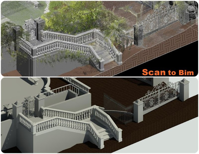
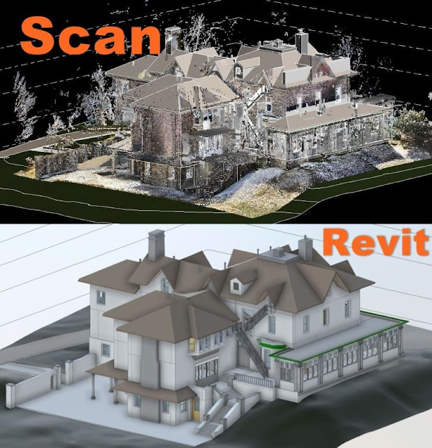
Tuesday 27 February 2024

As-Built Excellence Point Clouds in CAD Transformation

 Introduction:

In the realm of architecture, engineering, and construction, the accuracy and precision of as-built drawings are paramount. As-built drawings serve as the foundation for renovations, retrofitting, and maintenance projects, providing an accurate representation of existing structures. However, traditional methods of creating these drawings often fall short of capturing the intricate details and complexities of real-world environments. Enter point clouds and their transformative role in CAD (Computer-Aided Design) transformation. In this article, we delve into the concept of as-built excellence through the utilization of point clouds in CAD transformation.

As-built drawing, point cloud to cad


Point Cloud integration with CAD:

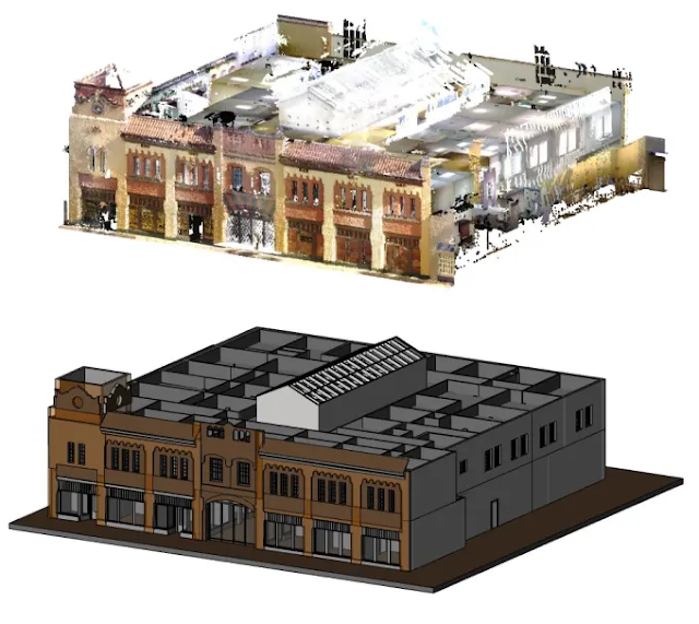
Point clouds, generated through laser scanning technology or photogrammetry, offer a comprehensive and detailed representation of physical spaces. These dense collections of points, each representing a precise location in three-dimensional space, capture the geometric and spatial characteristics of structures with unparalleled accuracy. When integrated into CAD software, point clouds serve as a valuable resource for creating precise and detailed as-built drawings.

Transformation process:

The transformation process begins with the acquisition of point cloud data through laser scanning or photogrammetry. High-resolution laser scanners emit laser beams that bounce off surfaces within a scene, measuring distances and recording millions of points. Similarly, photogrammetry techniques utilize overlapping photographs to reconstruct three-dimensional geometry. The result is a dense and detailed point cloud that accurately captures the existing conditions of a site or structure.

The transformation process into CAD from point cloud data initiates with the meticulous acquisition of spatial information through advanced technologies such as laser scanning or photogrammetry. High-resolution laser scanners, engineered with precision and sophistication, emit laser beams across the targeted environment. These beams bounce off surfaces, capturing intricate details by measuring distances and recording millions of individual points. Each point represents a specific location in the three-dimensional space, collectively forming what is known as a point cloud. This process ensures a thorough and comprehensive data collection, capturing even the most intricate architectural features, surface irregularities, and spatial complexities with unparalleled accuracy.

Once the point cloud data is obtained, it is imported into CAD software for processing and analysis. CAD software provides powerful tools for manipulating and extracting information from point cloud data, allowing users to create as-built drawings with exceptional accuracy. By overlaying the point cloud data onto the CAD environment, users can visualize the existing conditions of a structure in great detail, enabling precise measurements and annotations.

CAD transformation:

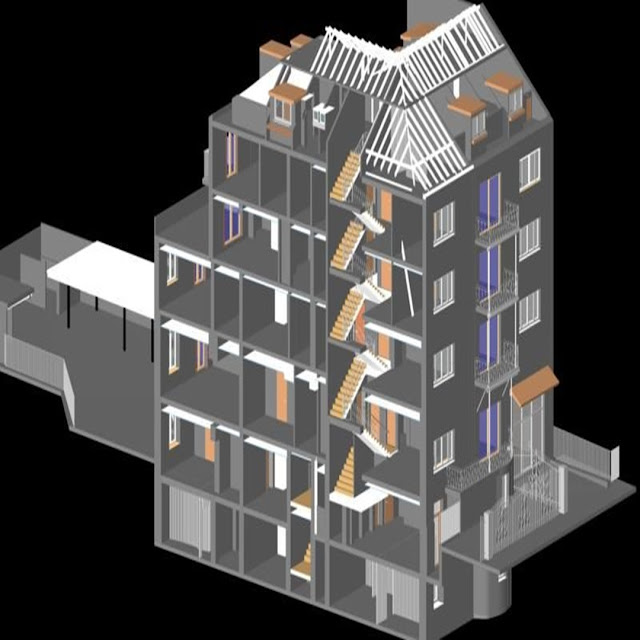
One of the key benefits of utilizing point clouds in CAD transformation is the ability to capture complex geometries and irregularities that may be challenging to document through traditional methods. Whether it's capturing the intricate details of historical architecture, accurately measuring existing structural elements, or assessing site conditions with precision, point clouds provide a level of detail and fidelity that is unmatched. This ensures that the resulting as-built drawings accurately reflect the real-world conditions of a structure, minimizing errors and discrepancies in the design and construction process.

Efficiency and productivity:

Moreover, the integration of point clouds into CAD software enhances the efficiency and productivity of the design process. By providing a comprehensive and accurate representation of existing structures, point clouds streamline the creation of as-built drawings, reducing the time and effort required to manually measure and document site conditions. This allows architects, engineers, and construction professionals to focus their efforts on design innovation and problem-solving, rather than tedious and time-consuming data collection tasks.

Collaboration and communication:

Furthermore, point clouds facilitate collaboration and communication among project stakeholders. By providing a visual representation of existing conditions, point clouds enable stakeholders to gain a deeper understanding of the project scope and challenges, fostering more informed decision-making processes. Whether it's communicating design intent to clients, coordinating with contractors on-site, or collaborating with fellow team members, point clouds serve as a valuable tool for enhancing communication and collaboration throughout the project lifecycle.

Design and construction:

In addition to their applications in design and construction, point clouds play a crucial role in facility management and asset documentation. By creating accurate as-built drawings using point cloud data, facility managers can effectively plan maintenance activities, manage assets, and optimize space utilization within a facility. This ensures that the facility operates efficiently and effectively, maximizing its lifespan and value.

Conclusion:

In conclusion, the integration of point clouds into CAD software represents a significant advancement in the creation of as-built drawings. By leveraging the rich spatial information captured through laser scanning technology or photogrammetry, architects, engineers, and construction professionals can create precise and detailed representations of existing structures with unparalleled accuracy. This enables them to make informed decisions, streamline workflows, and achieve as-built excellence in their projects. As the construction industry continues to embrace digital innovation, the use of point clouds in CAD transformation will undoubtedly play a pivotal role in shaping the future of design and construction practices.

Saturday 24 February 2024

Exploring Scan to CAD and BIM services

 Introduction:

Scan to CAD technology represents a significant advancement in the realm of design and engineering, offering a seamless transition from physical objects or spaces to digital representations. This process involves the conversion of real-world data obtained through 3D scanning into Computer-Aided Design (CAD) files. By bridging the gap between physical and digital realities, Scan to CAD enables designers and engineers to work with accurate and detailed models, revolutionizing various industries such as architecture, manufacturing, and urban planning. 

scan to cad, bim services


Understanding Scan to CAD and BIM Services:

Scan to CAD involves the conversion of point cloud data obtained from 3D laser scanning into CAD-compatible formats. This process facilitates the creation of accurate digital representations of physical objects or spaces, enabling architects and engineers to work with precise measurements and detailed models. This process involves the conversion of real-world data obtained through 3D scanning into Computer-Aided Design (CAD) files. By bridging the gap between physical and digital realities, Scan to CAD enables designers and engineers to work with accurate and detailed models, revolutionizing various industries such as architecture, manufacturing, and urban planning.

BIM incorporates geometric and spatial data, as well as information about materials, components, and building systems, providing a holistic view of a project throughout its lifecycle. BIM facilitates the creation and management of digital representations of physical and functional characteristics of projects throughout their lifecycle. This article explores the diverse range of BIM services, their benefits, and their transformative impact on the construction industry.

Integration of Scan to CAD and BIM:

The integration of Scan to CAD and BIM services offers numerous advantages for design and construction projects. By importing scanned data directly into BIM software, architects and engineers can seamlessly incorporate as-built conditions into their models. This integration enables clash detection, simulation, and visualization, allowing stakeholders to identify potential conflicts, analyze design alternatives, and make informed decisions early in the project lifecycle. Moreover, the combination of point cloud data with BIM enhances the accuracy and precision of models, reducing errors and rework during construction.

Benefits of Scan to CAD and BIM Services:

1. Enhanced Accuracy and Precision: Scan to CAD and BIM services enable designers to work with precise measurements and detailed models, ensuring accuracy throughout the design and construction process.

2. Improved Collaboration: By providing a centralized platform for sharing and accessing project data, Scan to CAD and BIM services facilitate collaboration among architects, engineers, contractors, and other stakeholders.

3. Time and Cost Savings: The streamlined workflows and clash detection capabilities offered by Scan to CAD and BIM services help reduce project timelines and minimize costly errors and rework.

4. Visualization and Simulation: Through the integration of scanned data with BIM models, stakeholders can visualize and simulate different design scenarios, enabling better decision-making and optimization of project outcomes.

5. Lifecycle Management: BIM serves as a valuable tool for facility management and maintenance, allowing owners to access comprehensive information about building components, systems, and performance.

Case Studies:

Several real-world examples illustrate the transformative impact of Scan to CAD and BIM services on design and construction projects. For instance, a large-scale renovation project utilized 3D laser scanning to capture as-built conditions of an existing building. The scanned data was then integrated into BIM software, allowing designers to accurately model proposed changes and identify clashes with existing structures. This approach helped streamline the design process, reduce rework, and ensure project deadlines were met.

Future Directions:

Looking ahead, the evolution of Scan to CAD and BIM services is poised to continue, driven by advancements in scanning technologies, artificial intelligence, and automation. Future developments may include real-time scanning and modeling capabilities, enhanced interoperability between different software platforms, and the integration of IoT (Internet of Things) data for smart building management. As these technologies become more sophisticated and accessible, their adoption is likely to become increasingly widespread across the AEC industry.

Conclusion:

In conclusion, Scan to CAD and BIM services represent a paradigm shift in the way design and construction projects are conceived, planned, and executed. By harnessing the power of scanning technologies and digital modeling, these services offer unparalleled opportunities to enhance accuracy, collaboration, and efficiency throughout the project lifecycle. As the industry continues to embrace these technologies, the possibilities for innovation and optimization are virtually limitless, promising a future where buildings are not just constructed, but intelligently designed and managed for maximum sustainability and performance.

Thursday 22 February 2024

Converting Point Clouds to BIM With Revit

 Introduction:

In the dynamic landscape of architecture, engineering, and construction (AEC) industries, the integration of cutting-edge technologies is revolutionizing traditional workflows. Among these advancements, the conversion of point clouds to Building Information Modeling (BIM) stands out as a transformative process, enabling professionals to bridge the gap between the physical world and digital design environments. At the forefront of this evolution is Autodesk Revit, a powerful software platform renowned for its capabilities in architectural design and project coordination. In this article, we explore the significance of converting point clouds to BIM with Revit, its applications across various sectors, and the benefits it offers to stakeholders.

point cloud to bim


Understanding Point Clouds and BIM:

Point clouds are three-dimensional representations of physical spaces, created through laser scanning or photogrammetry techniques. These dense datasets capture millions of points, each with precise spatial coordinates, providing a highly accurate depiction of existing conditions. Conversely, BIM is a digital representation of a building's physical and functional characteristics. It encompasses geometry, spatial relationships, geographic information, and other relevant data, fostering collaboration and facilitating informed decision-making throughout the project lifecycle.

The Integration Process:

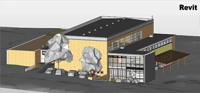
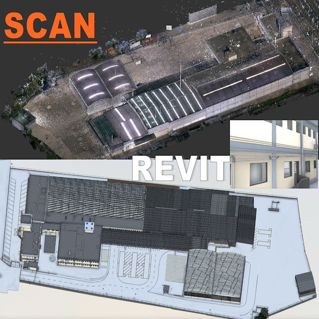
Converting point clouds to BIM with Revit involves a series of steps, each aimed at extracting meaningful information and translating it into a structured digital model. Initially, the point cloud data is imported into Revit using specialized plugins or native tools. Next, through point cloud processing software, such as Autodesk Recap, the data undergoes segmentation, noise reduction, and registration processes to enhance its quality and accuracy. Subsequently, using Revit's modeling tools, professionals begin the reconstruction phase, where they create parametric elements such as walls, floors, roofs, and structural components based on the point cloud reference. This meticulous process demands a combination of technical expertise, spatial awareness, and design proficiency to ensure fidelity to the existing conditions while adhering to project requirements and constraints.

Applications Across Industries:

The conversion of point clouds to BIM with Revit finds widespread applications across diverse industries, including architecture, engineering, construction, facilities management, and heritage preservation. In architectural design, for instance, it facilitates renovation projects by providing architects with a comprehensive understanding of the existing structure, enabling them to make informed design decisions and anticipate potential challenges. Similarly, in the construction phase, contractors leverage BIM models derived from point clouds to verify site conditions, detect clashes, and optimize construction sequencing, thereby improving efficiency and reducing rework. Moreover, in facility management, the integration of as-built BIM models supports ongoing operations and maintenance activities, empowering facility managers to streamline workflows, optimize space utilization, and ensure regulatory compliance.

Benefits and Advantages:

The conversion of point clouds to BIM with Revit offers a myriad of benefits to stakeholders throughout the project lifecycle. Firstly, it enhances decision-making by providing stakeholders with a comprehensive understanding of existing conditions, enabling them to mitigate risks, optimize resources, and drive innovation. Secondly, it improves collaboration and coordination among project teams by centralizing data in a standardized format, reducing errors, and minimizing information silos. Additionally, it enhances visualization capabilities, allowing stakeholders to explore virtual representations of physical spaces from multiple perspectives and analyze complex spatial relationships effectively. Furthermore, it fosters interoperability by enabling seamless data exchange between different software platforms and disciplines, promoting a holistic approach to project delivery and lifecycle management.

Overcoming Challenges and Considerations:

Despite its transformative potential, the conversion of point clouds to BIM with Revit is not without its challenges and considerations. The process requires significant computational resources and technical expertise, necessitating investment in hardware, software, and training. Moreover, ensuring the accuracy and reliability of the resulting BIM models demands meticulous quality control and validation procedures. Additionally, interoperability issues may arise when integrating BIM models with other software platforms or disciplines, highlighting the importance of standardized data formats and open collaboration frameworks. Furthermore, ethical and legal considerations regarding data ownership, privacy, and intellectual property rights must be addressed to ensure compliance with regulatory requirements and industry standards.

Conclusion:

In conclusion, RVTCAD the conversion of point clouds to BIM with Revit represents a paradigm shift in the AEC industries, enabling professionals to harness the power of digital technologies to enhance productivity, efficiency, and innovation. By seamlessly integrating reality capture techniques with advanced modeling capabilities, stakeholders can bridge the gap between physical environments and digital design workflows, unlocking new possibilities for collaboration, creativity, and sustainability. As the pace of technological advancement accelerates, the convergence of point clouds and BIM continues to redefine the future of architecture, engineering, and construction, empowering professionals to design, build, and operate the built environment more intelligently and effectively than ever before.

Tuesday 20 February 2024

Best Technique of Point Clouds Transformed into Revit Models

 Introduction:

Point cloud technology has revolutionized the way architects, engineers, and designers approach building information modeling (BIM). With its ability to capture precise spatial data, point clouds serve as a valuable resource for creating detailed and accurate 3D models. However, the process of transforming point clouds into Revit models requires skill, precision, and the right techniques to ensure optimal results. In this article, we delve into the best practices for seamlessly integrating point clouds into Revit, facilitating the creation of highly accurate and visually stunning models. The capacity to capture intricate spatial data has rendered point clouds an indispensable asset for crafting detailed and precise 3D models. Nonetheless, the journey from point clouds to Revit models demands a blend of skill, precision, and adept techniques to guarantee peak performance.

point clouds to revit


Understanding Point Cloud Data:

Before delving into the techniques, it's crucial to grasp the fundamentals of point cloud data. Point clouds are massive collections of 3D points, generated through LiDAR (Light Detection and Ranging) or photogrammetry techniques. These points collectively represent the surface of an object or environment, capturing intricate details such as geometry, texture, and color. However, raw point cloud data can be overwhelming, often containing millions of points that require processing and refinement for effective use in Revit. Point clouds are a collection of points in a three-dimensional coordinate system, representing the surfaces of objects within a scanned area.

Techniques for Point Cloud Processing:

1. Data Cleanup:

The initial step in transforming point clouds into Revit models involves data cleanup. This process entails removing noise, outliers, and unwanted elements from the point cloud dataset. Utilizing specialized software such as Autodesk Recap or Cloud Compare, users can employ filters and algorithms to enhance the quality of the point cloud, ensuring accurate representation of the scanned environment.

2. Point Cloud Registration:

Point cloud registration is essential for aligning multiple scans captured from different viewpoints into a cohesive 3D representation. By registering or aligning the scans accurately, inconsistencies and discrepancies can be minimized, resulting in a seamless transition between individual point clouds. Advanced registration algorithms offered by software like Leica Cyclone or FARO Scene facilitate precise alignment, enabling smoother integration into Revit.

3. Decimation and Simplification:

Given the vastness of point cloud data, decimation and simplification techniques are employed to reduce complexity while preserving essential details. Decimation involves selectively removing points from the dataset, ensuring optimal performance and manageable file sizes. Simplification techniques further refine the point cloud by grouping points into clusters or simplifying geometric shapes, striking a balance between detail preservation and computational efficiency.

Integration with Revit:

Once the point cloud data is processed and refined, the next step is integration with Revit for model creation. Revit offers native support for importing point cloud data, allowing users to overlay the point cloud onto the project environment as a reference. Through the "Point Cloud" feature, users can align, scale, and orient the point cloud within the Revit workspace, facilitating precise modeling based on real-world data.

Modeling from Point Clouds:

With the point cloud integrated into Revit, users can begin the modeling process by tracing and extrapolating geometry from the reference data. Utilizing Revit's suite of modeling tools such as walls, floors, and roofs, designers can accurately recreate the scanned environment within the BIM environment. By leveraging the point cloud as a guide, users can ensure dimensional accuracy and fidelity to the existing structure.

Detailing and Annotation:

Beyond basic geometry, point cloud data can inform the detailing and annotation process within Revit. By closely examining the point cloud, designers can identify intricate features, such as architectural elements, structural components, and MEP (Mechanical, Electrical, Plumbing) systems. Leveraging Revit's annotation tools, users can add precise dimensions, labels, and notes directly onto the model, enhancing communication and facilitating collaboration among project stakeholders.

Conclusion:

RVTCAD Transforming point clouds into Revit models represents a powerful synergy between reality capture and building information modeling. By employing techniques such as data cleanup, registration, and simplification, designers can harness the full potential of point cloud data to create accurate and detailed models within the Revit environment. As technology continues to advance, the seamless integration of point clouds into BIM workflows promises to redefine the way we conceptualize, design, and construct the built environment. The fusion of point clouds and Revit models epitomizes a formidable convergence of reality capture and building information modeling (BIM). Through adept utilization of methodologies like data cleanup, registration, and simplification, designers unlock the true potential of point cloud data, enabling the creation of precise and intricate models within the Revit ecosystem.

Saturday 17 February 2024

Advancing As-Built Drawings Through 3D Laser Scanning

 Introduction:

In the realm of architecture, engineering, and construction (AEC), the accuracy and comprehensiveness of as-built drawings serve as the cornerstone for successful projects. Traditionally, generating these drawings has been a labor-intensive process fraught with challenges such as inaccuracies, time constraints, and limited data capture methods. However, the advent of 3D laser scanning has heralded a new era, offering unparalleled precision, efficiency, and depth of information. This article delves into the transformative potential of 3D laser scanning in advancing the creation and utilization of as-built drawings, revolutionizing the AEC industry.

As-built drawings, 3d laser scanning


Capturing Reality with Unprecedented Detail:

At the heart of 3D laser scanning lies its ability to capture reality with unparalleled detail and accuracy. Unlike conventional surveying techniques, which often rely on manual measurements and are prone to human error, 3D laser scanning employs laser beams to precisely measure distances and capture spatial data. This technology enables the rapid and comprehensive digitization of physical environments, including intricate architectural details, structural components, and spatial relationships. By creating a highly detailed digital replica of existing structures, 3D laser scanning lays the foundation for the creation of as-built drawings that are not only accurate but also rich in contextual information.

Streamlining Data Acquisition and Processing:

One of the most significant advantages of 3D laser scanning is its ability to streamline the data acquisition and processing workflow. Traditional methods of data collection, such as manual surveying or photogrammetry, are time-consuming and often require multiple site visits. In contrast, 3D laser scanning allows for rapid data capture, significantly reducing the time and resources required for as-built documentation. Moreover, the captured data can be easily processed using advanced software tools, enabling swift extraction of key information such as dimensions, elevations, and geometric relationships. This streamlined workflow accelerates the generation of precise as-built drawings, empowering project teams to make informed decisions and progress more efficiently.

Enhancing Accuracy and Precision:

Accuracy is paramount in as-built drawings, as even minor discrepancies can have significant implications for project execution and long-term maintenance. 3D laser scanning excels in delivering high-fidelity data, eliminating many of the errors inherent in traditional surveying methods. By capturing millions of data points with sub-millimeter precision, this technology ensures that as-built drawings faithfully represent the true dimensions and conditions of existing structures. Furthermore, 3D laser scanning enables the detection of deviations from design intent or construction tolerances, allowing for proactive resolution of issues before they escalate. The result is as-built drawings that serve as reliable reference documents for all stakeholders involved in the project lifecycle.

Facilitating Collaboration and Communication:

Effective collaboration is essential for the success of any construction project, and as-built drawings play a crucial role in facilitating communication among project stakeholders. 3D laser scanning enhances collaboration by providing a shared, digital representation of the project site that can be accessed remotely by team members across different locations. By visualizing complex spatial data in an intuitive 3D environment, as-built drawings generated from laser scanning foster greater understanding and alignment among architects, engineers, contractors, and clients. This enhanced communication leads to more informed decision-making, reduced misunderstandings, and ultimately, better project outcomes.

Unlocking New Possibilities in Design and Retrofitting:

Beyond their role in documenting existing conditions, as-built drawings derived from 3D laser scanning unlock new possibilities in design innovation and retrofitting projects. The rich spatial data captured during scanning can serve as a foundation for Building Information Modeling (BIM), enabling architects and engineers to explore design alternatives and conduct virtual simulations with unprecedented accuracy. Additionally, 3D laser scanning facilitates the integration of new building elements or infrastructure upgrades into existing structures with precision, minimizing conflicts and maximizing efficiency. Whether it's optimizing space utilization, improving energy efficiency, or enhancing accessibility, the detailed insights provided by 3D laser scanning empower designers to push the boundaries of what's possible in building design and renovation.

Conclusion:

In conclusion, the integration of 3D laser scanning represents a paradigm shift in the creation and utilization of as-built drawings within the AEC industry. By harnessing the power of advanced technology to capture reality with unparalleled accuracy, efficiency, and depth, RVTCAD 3D laser scanning has redefined the possibilities of as-built documentation. From streamlining data acquisition and processing to enhancing collaboration and enabling design innovation, the benefits of 3D laser scanning extend across the entire project lifecycle, ultimately driving improved outcomes and delivering greater value to stakeholders. As the technology continues to evolve, its transformative impact on the AEC industry is poised to reshape the way we conceive, construct, and interact with the built environment.

Thursday 15 February 2024

Power of Scan to Revit and Point Cloud to BIM Services

 Introduction:

In the ever-evolving landscape of architecture, engineering, and construction (AEC) industries, the demand for efficient, accurate, and innovative solutions is incessant. One such revolutionary tandem that has reshaped the way projects are conceptualized, designed, and executed is the fusion of Scan to Revit and Point Cloud to BIM (Building Information Modeling) services. This dynamic duo not only expedites the conversion of real-world data into digital models but also enhances collaboration, reduces errors, and empowers decision-making throughout the project lifecycle.

scan to revit, point cloud to bim services


What is the process of Scan to Revit?

Scan to Revit is a process that involves capturing detailed as-built data of existing structures using advanced scanning technologies such as LiDAR (Light Detection and Ranging) or photogrammetry. This data is then imported into Autodesk Revit, a leading BIM software, where it is transformed into intelligent 3D models. On the other hand, Point Cloud to BIM services entail the conversion of point cloud data, generated from laser scanning or drone surveys, into BIM-compatible models. While these services have distinct functionalities, their integration amplifies their capabilities, offering a comprehensive solution for as-built modeling and renovation projects.

The cornerstone of Scan to Revit and Point Cloud to BIM services lies in their ability to bridge the gap between the physical and digital realms with unparalleled precision. Traditional methods of manual measurement and drafting are time-consuming, prone to errors, and often lack the level of detail required for complex projects. By leveraging laser scanning technology, these services enable the rapid capture of millions of data points, resulting in highly accurate representations of existing conditions. This rich dataset serves as the foundation for creating parametric BIM models in Revit, facilitating a seamless transition from the real world to the virtual environment.

Advantages of Scan to Revit and Point Cloud to BIM:

One of the most compelling advantages of Scan to Revit and Point Cloud to BIM services is their capacity to streamline the renovation and retrofitting process. Whether it's a historical landmark undergoing restoration or a commercial facility undergoing expansion, these services provide architects and engineers with invaluable insights into the existing structure. By overlaying point cloud data onto BIM models, stakeholders can identify clashes, discrepancies, and spatial constraints early in the design phase, thereby minimizing costly redesigns and construction delays. Furthermore, the ability to visualize proposed changes within the context of the existing environment enhances stakeholder communication and fosters informed decision-making.

Integration of Scan to Revit and Point cloud to BIM:

The integration of Scan to Revit and Point Cloud to BIM services also revolutionizes facility management and maintenance practices. Traditionally, facility managers grapple with outdated or incomplete documentation, making it challenging to assess the condition of assets, plan maintenance schedules, and allocate resources efficiently. By digitizing as-built information and integrating it into BIM platforms, facility managers gain access to a centralized repository of data that provides a holistic view of the facility's infrastructure. This digital twin not only facilitates asset tracking and lifecycle management but also supports predictive maintenance strategies through real-time monitoring and analysis.

Services of Scan to Revit and Point Cloud to BIM:

Moreover, scan to Revit and Point Cloud to BIM services play a pivotal role in enhancing safety and mitigating risks on construction sites. The ability to generate comprehensive 3D models enables stakeholders to conduct clash detection analyses, identify potential hazards, and optimize construction sequencing. Additionally, the integration of BIM with construction management software enables project teams to simulate construction processes, identify logistical challenges, and devise mitigation strategies before breaking ground. By proactively addressing safety concerns and optimizing workflow efficiency, these services contribute to a safer, more productive work environment.

Transformative potential:

However, despite their transformative potential, the widespread adoption of Scan to Revit and Point Cloud to BIM services is not without its challenges. Chief among these challenges is the complexity of data integration and interoperability between disparate software platforms. As projects grow in scale and complexity, ensuring seamless data exchange becomes increasingly crucial to avoid fragmentation and data loss. Furthermore, the initial investment in scanning equipment and software licenses may deter smaller firms from embracing these technologies, necessitating industry-wide collaboration and knowledge sharing to democratize access.

Conclusion:

In conclusion, the fusion of Scan to Revit and Point Cloud to BIM services represents a paradigm shift in the AEC industries, empowering stakeholders with unprecedented insights and capabilities. From accurate as-built documentation to enhanced collaboration and risk mitigation, the benefits of these services extend across the entire project lifecycle. As technology continues to advance and barriers to adoption diminish, scan to Revit and Point Cloud to BIM services will undoubtedly continue to redefine the way we design, construct, and manage the built environment. Embracing this transformative synergy is not merely an option but an imperative for staying competitive in an increasingly digital world.

Tuesday 13 February 2024

Best Technique of BIM Laser Scanning and Scan to Cad

 Introduction:

In the ever-evolving landscape of design and construction, precision and efficiency are paramount. Two techniques that have revolutionized the industry are Scan to CAD and BIM (Building Information Modeling) Laser Scanning. These methodologies have not only enhanced accuracy but have also significantly streamlined workflows. In this article, we delve into the best techniques of Scan to CAD and BIM Laser Scanning, elucidating their benefits and exploring how they are shaping the future of design and construction.

bim laser scanning, scan to cad


The Power of Scan to CAD:

Scan to CAD is a transformative process that involves converting point cloud data captured from laser scanning into accurate and detailed CAD (Computer-Aided Design) models. One of the standout techniques in this process is feature extraction. This method utilizes advanced algorithms to automatically identify and extract key features from the point cloud, such as walls, doors, and windows. By automating this process, designers can save considerable time and effort while ensuring precision in their models.

Another notable technique is surface reconstruction. This involves generating surfaces from the point cloud data, allowing designers to create solid models that accurately represent the scanned environment. Advanced surface reconstruction algorithms ensure that the resulting CAD models maintain the intricacies and nuances of the original structure, facilitating more informed design decisions.

Furthermore, the integration of Scan to CAD with BIM software has further enhanced its capabilities. By combining point cloud data with BIM models, designers can create comprehensive digital representations of both existing and proposed structures. This integration enables clash detection, spatial analysis, and visualization, empowering designers to identify potential conflicts and optimize designs before construction begins.

The Precision of BIM Laser Scanning:

BIM Laser Scanning is another indispensable technique that has revolutionized the design and construction industry. This methodology involves using laser scanners to capture detailed 3D measurements of existing structures, providing an accurate digital representation of the built environment. One of the key techniques in BIM Laser Scanning is high-density scanning. By capturing millions of data points per second, high-density scanning ensures that every detail of the structure is accurately captured, from intricate architectural features to structural elements.

Another crucial technique is registration and alignment. This involves combining multiple scans of the same environment to create a cohesive and accurate 3D model. Advanced registration algorithms automatically align scans based on common features, minimizing errors and discrepancies in the final model. This technique is essential for large-scale projects where multiple scans are required to capture the entire structure.

Additionally, BIM Laser Scanning offers real-time visualization capabilities, allowing designers to visualize scanned data within BIM software instantly. This enables stakeholders to explore and analyse the scanned environment from various perspectives, facilitating better decision-making throughout the design process.

How RvtCAD Provide these services?

Rvtcad providing Scan to CAD and BIM Laser Scanning services typically initiate projects with thorough consultations to understand client objectives and project scope. Following this, they conduct meticulous site assessments and employ advanced laser scanning technology to capture detailed 3D measurements of existing structures. Data processing techniques, such as feature extraction and surface reconstruction, are then applied to convert raw point cloud data into accurate CAD models or BIM files. Rigorous quality assurance procedures ensure the accuracy and completeness of the final deliverables before they are provided to the client for review. Throughout the process, companies prioritize client satisfaction, offering ongoing support and technical assistance to ensure effective utilization of the CAD models or BIM files in the client's projects.

Conclusion:

Scan to CAD and BIM Laser Scanning represent the pinnacle of technological innovation in design and construction. These techniques not only enhance accuracy and precision but also significantly streamline workflows, ultimately leading to more efficient and cost-effective projects. By leveraging the best techniques of Scan to CAD and BIM Laser Scanning, designers and engineers can create comprehensive digital representations of existing structures and streamline the design process from concept to completion. As technology continues to advance, these techniques will undoubtedly play an increasingly vital role in shaping the future of design and construction.

In conclusion, the integration of Scan to CAD and BIM Laser Scanning techniques offers unparalleled opportunities for innovation and efficiency in the design and construction industry. By embracing these methodologies and leveraging their capabilities, designers and engineers can unlock new possibilities and redefine the standards of excellence in their respective fields.

Saturday 10 February 2024

Transforming Point Cloud Data into As-Built Drawings

Introduction:

In the realm of construction and architecture, precision is paramount. Accuracy in as-built drawings—the finalized plans that reflect the actual constructed elements—is critical for efficient project management, renovations, and facility management. Traditionally, creating these drawings involved time-consuming manual measurements, leading to potential errors and delays. However, the advent of point cloud technology has revolutionized this process, offering a faster, more accurate, and comprehensive solution. In this article, we delve into the transformative power of transforming point cloud data into as-built drawings.

point cloud to bim, as-built drawings


Understanding Point Cloud Technology:

Point cloud technology revolutionizes spatial data capture and representation by meticulously recording millions of data points that precisely capture the three-dimensional coordinates of surfaces, objects, and environments. Utilizing advanced techniques such as laser scanning and photogrammetry, point clouds offer unparalleled accuracy and detail, making them indispensable in various industries including construction, architecture, engineering, surveying, and archaeology. These dense datasets serve as the foundation for creating highly accurate as-built models, facilitating infrastructure assessment, topographic mapping, and archaeological documentation. Despite challenges in data management and processing, the versatility and potential of point cloud technology to drive innovation and enhance visualization, simulation, and analysis experiences are undeniable, shaping the future of how we perceive and interact with the physical world.

 As-Built Drawings:

As-built drawings serve as the blueprint of reality, documenting the precise dimensions, locations, and configurations of structural elements, utilities, and other features post-construction. They are invaluable for retrofitting, remodeling, maintenance, and future planning. Traditionally, creating these drawings involved manual measurements, often leading to inaccuracies and discrepancies between the planned and actual structures. Traditionally, creating as-built drawings involved labor-intensive manual measurements, often prone to inaccuracies and discrepancies. However, advancements in technology, such as point cloud scanning and Building Information Modeling (BIM), have revolutionized this process. By leveraging point cloud data, architects and engineers can generate highly accurate representations of existing conditions, streamlining the documentation process and minimizing the risk of errors. As-built drawings serve as a cornerstone for efficient project management and decision-making, ensuring that construction projects are executed with precision and adherence to design intent.

Streamlining the Process:

Point cloud technology streamlines the process of generating as-built drawings by providing a comprehensive and accurate representation of the existing conditions. Instead of relying on manual measurements, architects and engineers can leverage point cloud data to extract the necessary information directly from the scanned environment. This eliminates the need for extensive site visits and minimizes the risk of errors.

Extraction and Modeling:

The transformation of point cloud data into as-built drawings involves several key steps. First, the raw point cloud data is processed and cleaned to remove noise and outliers, ensuring the accuracy of the subsequent analysis. Next, specialized software tools are employed to segment the point cloud into distinct elements, such as walls, floors, ceilings, and structural components. These elements are then modeled in a Building Information Modeling (BIM) software, where additional information, such as material properties and system specifications, can be added.

Accuracy and Detail:

One of the primary advantages of using point cloud data for as-built drawings is the unparalleled level of accuracy and detail it provides. Unlike traditional surveying methods, which are prone to human error and limitations, point cloud technology captures every nook and cranny of the scanned environment with precision. This ensures that the resulting as-built drawings faithfully represent the actual conditions on-site, reducing the risk of costly mistakes during renovations or construction projects.

Time and Cost Savings:

In addition to improving accuracy, transforming point cloud data into as-built drawings offers significant time and cost savings. By eliminating the need for manual measurements and site visits, architects and engineers can expedite the documentation process and allocate resources more efficiently. This enables faster decision-making, reduces project timelines, and ultimately lowers project costs.

Enhancing Collaboration and Communication:

Point cloud technology also facilitates collaboration and communication among project stakeholders. By providing a highly detailed and immersive representation of the scanned environment, it allows architects, engineers, contractors, and clients to visualize the project in its entirety. This shared understanding fosters better decision-making, enhances coordination, and minimizes misunderstandings throughout the project lifecycle.

Conclusion:

Transforming point cloud data into as-built drawings represents a significant leap forward in construction documentation and project management. By harnessing the power of laser scanning and photogrammetry, architects and engineers can create highly accurate and detailed representations of existing structures, streamlining the renovation process, and improving project outcomes. As the technology continues to evolve and become more accessible, its potential to revolutionize the construction industry is undeniable. Embracing point cloud technology is not just about staying ahead of the curve—it's about reshaping the way we build, one data point at a time. 

Thursday 8 February 2024

Best Visualizing Reality With 3D Laser Scanning in Revit

Introduction:

In the domain of architectural and engineering design, the ability to accurately visualize reality is paramount. Traditional methods of measurement and modeling often fall short in capturing intricate details and nuances of existing structures or environments. However, with the advent of 3D laser scanning technology, coupled with the powerful capabilities of Building Information Modeling (BIM) software like Revit, architects, engineers, and designers now have the tools to create highly detailed and precise digital representations of real-world spaces.

3d laser scanning, as-built 3d services


Understanding 3D Laser Scanning:

3D laser scanning is a cutting-edge technology that enables the rapid and accurate capture of physical environments in three dimensions. By emitting laser beams and measuring the time it takes for the light to return, laser scanners can create precise point cloud data representing the geometry and attributes of objects within their field of view. This data forms the basis for creating detailed digital models of existing structures or environments. This technology has gained popularity across various industries due to its ability to create highly accurate and detailed representations of real-world objects and spaces.

Integration with Revit:

Revit, a BIM software developed by Autodesk, is widely used in the architecture, engineering, and construction industries for designing and documenting building projects. Its robust features allow users to create intelligent 3D models that encompass both the physical and functional characteristics of a building. Integration with 3D laser scanning technology enhances Revit's capabilities by providing accurate as-built data for existing structures, which can be used as a reference for renovation, retrofitting, or preservation projects.

Advantages of Visualizing Reality with 3D Laser Scanning in Revit:

Accuracy and Precision: 3D laser scanning captures precise measurements and details of existing structures, ensuring accuracy in the digital model created in Revit. This level of precision is crucial for design decisions, clash detection, and coordination among project stakeholders.

Time and Cost Efficiency:

Traditional methods of manually measuring and documenting existing structures can be time-consuming and labour-intensive. 3D laser scanning significantly reduces the time and effort required for data collection, thereby saving both time and costs during the design process.

Comprehensive Data Capture:

Laser scanning captures not only the geometric dimensions of objects but also their visual appearance and contextual information. This comprehensive data allows designers to accurately represent the existing conditions of a site or building in the Revit model.

Enhanced Collaboration:

The detailed 3D models created with laser scanning can be easily shared and collaborated upon within the Revit environment. This facilitates better communication among project team members, enabling them to make informed decisions and resolve design challenges more efficiently.

 Risk Mitigation:

By providing an accurate representation of existing conditions, 3D laser scanning helps mitigate risks associated with design errors, construction delays, and cost overruns. Design decisions can be made with confidence, knowing that they are based on reliable data.

Case Studies and Real-World Applications

Numerous real-world projects demonstrate the benefits of visualizing reality with 3D laser scanning in Revit. From historic preservation efforts to large-scale renovation projects, architects and engineers leverage this technology to streamline workflows, improve design accuracy, and deliver superior results.

For example, in the renovation of a historic landmark, 3D laser scanning was used to capture detailed measurements of the existing structure, including intricate architectural features and ornamentation. This data was then imported into Revit, where designers could accurately model proposed modifications while preserving the historical integrity of the building.

In another scenario, a construction firm utilized 3D laser scanning to verify the as-built conditions of a complex industrial facility before beginning renovation work. By comparing the scanned data with the original design plans in Revit, they were able to identify discrepancies and conflicts early in the process, avoiding costly rework and delays during construction.

Conclusion:

Rvtcad Visualizing reality with 3D laser scanning in Revit represents a paradigm shift in the way architects, engineers, and designers approach building projects. By harnessing the power of laser scanning technology and integrating it with the capabilities of Revit, professionals can create highly accurate and detailed digital models that serve as the foundation for successful design and construction endeavours. As the technology continues to evolve and become more accessible, its role in shaping the built environment will only continue to grow, driving innovation and efficiency across the industry. 

Monday 5 February 2024

Point Cloud and Scan to BIM Transforming Revit workflows

 Introduction:

In the ever-evolving landscape of architectural design and construction, technology emerges as a guiding force, reshaping the approaches of industry professionals. A revolutionary fusion that stands at the forefront is the seamless integration of Point Clouds and Scan to BIM into the familiar realm of Autodesk Revit. Beyond being a mere technological leap, this potent amalgamation acts as a transformative catalyst, redefining conventional workflows and propelling precision to new heights within the realm of Building Information Modeling (BIM). As the threads of digital innovation interweave with the tangible world, this unique alliance not only signifies a technological evolution but also marks the inception of a paradigm where architectural accuracy and efficiency transcend existing boundaries.

point cloud to bim, Scan to bim


Understanding Point Clouds and Scan to BIM:

Before delving into their impact on Revit workflows, it's crucial to understand the key components at play. Point Clouds are massive sets of 3D data points, typically captured through laser scanning or photogrammetry. These detailed and accurate representations of physical spaces serve as the foundation for creating digital twins of existing structures. Scan to BIM, on the other hand, is the process of converting these intricate Point Clouds into Building Information Models. This involves extracting relevant information, such as geometry, spatial relationships, and other valuable data, and seamlessly integrating it into the BIM environment. The result is a comprehensive digital model that mirrors the real-world structure with unparalleled accuracy.

The Transformative Power in Revit Workflows:

·         Precision Redefined:

The integration of Point Clouds and Scan to BIM in Revit redefines precision in architectural modeling. Traditional methods often rely on manual measurements and interpretation, leaving room for errors. With the accurate data from Point Clouds, every detail is captured with unparalleled precision, ensuring that the digital representation mirrors the physical reality to the minutest detail. Leveraging the laser-sharp precision inherent in Point Cloud data, every nuance and intricacy of the physical environment is not just captured but meticulously mirrored in the digital realm. The result is a level of accuracy that transcends the limitations of conventional modeling approaches, setting a new standard for precision in the architectural design and construction landscape.

·         Efficient As-Built Modeling:

Revit has long been the go-to platform for as-built modeling, enabling architects and engineers to work on existing structures and renovations. However, the introduction of Point Clouds and Scan to BIM takes efficiency to new heights. Instead of relying on time-consuming site measurements and manual input, professionals can directly import Point Clouds into Revit, allowing for a faster and more accurate representation of the as-built environment.

·         Streamlined Collaboration:

Collaboration among various stakeholders is a cornerstone of successful construction projects. Point Clouds, integrated through Scan to BIM, provide a common and accurate reference point for architects, engineers, and contractors. This shared digital representation ensures that everyone is working from the same accurate data, reducing misunderstandings and streamlining communication throughout the project lifecycle.

·         Enhanced Design Validation:

Architects often face challenges in validating their designs against existing structures. Point Clouds enable a more thorough design validation process by providing a comprehensive view of the as-built environment. This ensures that design decisions are made with full awareness of the existing conditions, minimizing the likelihood of clashes or conflicts during construction.

·         Cost and Time Savings:

Time is money in the construction industry, and the integration of Point Clouds and Scan to BIM directly addresses this concern. By eliminating the need for extensive manual measurements and reducing rework due to inaccuracies, professionals can realize significant time and cost savings. The upfront investment in scanning technology is quickly outweighed by the efficiency gains throughout the project lifecycle.

How Rvtcad provide these services?
Rvtcad provides Point Clouds and Scan to BIM services employ a systematic approach to seamlessly integrate precise 3D data into comprehensive Building Information Models (BIM). The process begins with the acquisition of data through laser scanning or photogrammetry, capturing intricate details of the physical environment. Specialized software, including Scan to BIM tools and platforms like Autodesk Revit, is then utilized to integrate the collected Point Cloud data. Skilled professionals meticulously extract and model architectural and structural elements, ensuring a faithful representation of the real-world conditions.

Conclusion:

Point Clouds and Scan to BIM within the Revit environment marks a transformative shift in how professionals’ approach architectural design and construction. The seamless integration of precise data not only enhances the accuracy of digital models but also streamlines workflows, fosters collaboration, and ultimately contributes to more successful and efficient construction projects. As the industry continues to embrace these technologies, the potential for innovation and optimization in Revit workflows becomes limitless. Architects, engineers, and construction professionals are empowered with tools that not only respect the intricacies of existing structures but also pave the way for a future where digital models seamlessly mirror the physical world, ensuring a new era of precision and efficiency in the built environment.


Friday 2 February 2024

Scan to CAD and the beauty of As-Built Precision

 Introduction:

In the ever-evolving realm of design and architecture, the integration of advanced technologies has become pivotal in ensuring precision, efficiency, and aesthetic appeal. One such transformative process that has gained prominence is Scan to CAD, a technique that not only bridges the gap between the physical and digital worlds but also elevates the creation of As-Built drawings to a level of unparalleled precision and beauty.

scan to bim, as-built drawing


The Evolution of Scan to CAD: Beyond Traditional Boundaries

Historically, creating accurate representations of existing structures for renovation or retrofitting purposes involved intricate manual measurements, often leading to human errors and discrepancies. The advent of Scan to CAD technology marked a paradigm shift, offering a streamlined and highly accurate approach. Scan to CAD involves the use of 3D laser scanners or other advanced surveying tools to capture detailed point clouds of the existing structure. These point clouds, essentially a three-dimensional representation of the physical space, serve as the foundation for the creation of CAD models. The precision achieved through this method ensures that every nuance and detail of the real-world structure is faithfully translated into the digital domain.

Unveiling the Beauty of As-Built Precision:

The beauty of Scan to CAD lies in its ability to faithfully reproduce the intricacies of existing structures with a level of precision that was once hard to fathom. Traditional methods often left room for interpretation and approximation, leading to designs that deviated from the actual dimensions and details of the structure. With Scan to CAD, the digital models generated are a true reflection of reality. Every nook, cranny, and architectural feature is captured with meticulous accuracy. This precision not only enhances the integrity of the design process but also serves as a testament to the evolving synergy between technology and creativity.

Efficiency Redefined: From Scan to CAD to As-Built Drawings

The transition from Scan to CAD to As-Built drawings represents a seamless fusion of technology and creativity. Once the point clouds are captured, advanced software is employed to convert this data into a detailed CAD model. This digital representation becomes the canvas for architects and designers to work upon, ensuring that modifications and additions are made with a deep understanding of the existing structure. The beauty of As-Built precision is further accentuated by the efficiency gained in the design process. Traditional methods often required multiple rounds of measurements and adjustments, leading to extended timelines and increased costs. Scan to CAD expedites this process, allowing for quicker decision-making and a more agile approach to design.

Enhancing Collaboration and Communication:

Scan to CAD not only enhances precision in design but also fosters improved collaboration among stakeholders. Architects, engineers, and builders can work from a common digital model, eliminating the ambiguity that often arises from traditional 2D drawings. This shared understanding of the structure ensures that everyone involved in the project is on the same page, ultimately contributing to a more harmonious and efficient construction process.

Future Prospects: Innovations in Scan to CAD Technology

As technology continues to advance, the future of Scan to CAD holds exciting possibilities. Integration with artificial intelligence and machine learning algorithms is poised to further enhance the efficiency and accuracy of the process. Additionally, the development of more portable and cost-effective scanning devices is making Scan to CAD accessible to a broader range of professionals and projects.

Conclusion: A New Era of Architectural Precision

In the realm of design and architecture, Scan to CAD has ushered in a new era characterized by precision, efficiency, and a profound appreciation for the beauty of As-Built structures. The marriage of cutting-edge technology and creative vision has not only revolutionized the way we approach design but has also elevated the standards for accuracy and detail. As we continue to embrace and refine Scan to CAD techniques, the beauty of As-Built precision will undoubtedly shape the future of architectural innovation. As we stand at the forefront of architectural innovation, the integration of Rvtcad with Scan to CAD represents a harmonious blend of tradition and technology, where the past meets the future, and the beauty of As-Built precision is not just a goal but a realized standard in the ever-evolving landscape of design and construction.

Point Cloud to BIM Modeling | Scan to BIM Conversion | Rvtcad

  Introduction The process known as " Point Cloud to BIM Modeling" entails creating Building Information Models (BIM) using sca...